Well what a day we have had, we woke at 4am to be at Stonehenge by 6am, we drove as the sun rose and through fog and rain. We arrived by 5.45am and by then the rain had stopped so we were very happy. We commenced our personal tour with 24 others of the henge at 6.15am allowed past the ropes and up close and personal with the stones. What an amazing feeling to stand amongst these giants. We had about 1/2 hour of being in the henge when the sun broke through and it was like a whole another experience and we then had another 1/2 hour amongst the golden stones with the suns rays bringing them to life.
Stonehenge is probably the most important prehistoric monument in the whole of Britain and it stands as a timeless monument to the people who built it. The stonehenge that we see today is the final stage that was completed about 3500 years ago, but first let us look back 5000 years. The first Stonehenge was a large earthwork or Henge, comprising a ditch, bank, and the Aubrey holes, all probably built around 3100 BC. The Aubrey holes are round pits in the chalk, about one metre wide and deep, with steep sides and flat bottoms. They form a circle about 284 feet in diameter. Excavations have revealed cremated human bones in some of the chalk filling, but the holes themselves were probably made, not for the purpose of graves, but as part of the religious ceremony.
Shortly after this stage Stonehenge was abandoned, left untouched for over 1000 years. The second and most dramatic stage of Stonehenge started around 2150 BC. Some 82 bluestones from the Preseli mountains, in south-west Wales were transported to the site. It is thought these stones, some weighing 4 tonnes each were dragged on rollers and sledges to the headwaters on Milford Haven and then loaded onto rafts. They were carried by water along the south coast of Wales and up the rivers Avon and Frome, before being dragged overland again to near Warminster in Wiltshire.
The final stage of the journey was mainly by water, down the river Wylye to Salisbury, then the Salisbury Avon to west Amesbury. This astonishing journey covers nearly 240 miles. Once at the site, these stones were set up in the centre to form an incomplete double circle. ( During the same period the original entrance of the circular earthwork was widened and a pair of Heel Stones were erected. Also the nearer part of the Avenue was built, aligned with the midsummer sunrise.)
The third stage of Stonehenge, about 2000 BC, saw the arrival of the Sarsen stones, which were almost certainly brought from the Marlborough Downs near Avebury, in north Wiltshire, about 25 miles north of Stonehenge. The largest of the Sarsen stones transported to Stonehenge weigh 50 tonnes and transportation by water would have been impossible, the stones could only have been moved using sledges and ropes. Modern calculations show that it would have taken 500 men using leather ropes to pull one stone, with an extra 100 men needed to lay the huge rollers in front of the sledge. These were arranged in an outer circle with a continuous run of lintels. Inside the circle, five trilithons were placed in a horseshoe arrangement, whose remains we can still see today.
The final stage took place soon after 1500 BC when the bluestones were rearranged in the horseshoe and circle that we see today. The original number of stones in the bluestone circle was probably around 60, these have long since been removed or broken up. Some remain only as stumps below ground level. The 'Avenue' the outermost element of the site is the 'Avenue' that runs away from the site down a gentle slope for 530m into Stonehenge Bottom (and the River Avon). The Avenue consists of twin banks about 12m (40ft) apart with internal ditches which begin at the entrance to the earthwork enclosure and terminate at the River Avon. The Stonehenge end of the avenue is aligned to the summer solstice sunrise, with the other end terminating at another henge/circle by the River Avon. It has been recently realised (2009), that the other end of the 'Avenue' also once had a henge-circle at its terminus. This newly discovered part of the Stonehenge landscape has been dubbed 'Bluestonehenge', due to the fact that it was formed of 24/25 'Bluestone' menhirs, currently thought to have been later moved to Stonehenge during the second phase of construction. The discovery another such monument on the supports the idea of an intimate connection between the megliths, the landscape, the visible heavens and the after-life.
River Avon is the sacred giver of life the avenue ends near Church Street bridge in Amesbury. Several sarsen uprights have prehistoric carvings on their sides. The earliest of these, high up on the inside face of the fourth trilithon of the horseshoe, is a shallow oblong shape thought to be similar to carvings found in Neolithic stone burial chambers in Brittany, which are sometimes thought to represent in a simplified and symbolic way the figure of a mother goddess. This carving is out of reach of the ground and was therefore made, probably, before the stone was set up. The carvings on the other stones are all nearer the ground, and probably made after the stones had been erected. Most of them are full size representations of bronze axe-heads of the Early Bronze Age, of a kind commonly made in Britain and Ireland between 1800BC and 1500BC, but there is one carving also of a bronze dagger, which could represent a foreign dagger, of the kind found in the Shaft Graves of Mycenae in Greece, though doubt has been cast on this hypothesis.


 |
| The chiselled hole to sit the stone on top of the upright stone forming a ball and socket type fitting |
 |
| This stone is known as the slaughter stone even though it is thought no sacrifices were made |
 |
| Looking from the centre of the henge through to the heel stone where the summer solstice sunrise rises |
 |
| Graffetti of Chrispher Wren |
 |
| The carving of a dagger on the left then an axe head and towards the right three more axes (very shallow) |
After our Stonehenge experience we drove to the River Avon on Bridge Street Amesbury where the avenue from Stonehenge finishes and the Queensberry Bridge built in 1779 is.
 |
| It was such a beautiful place so I decided it would be a fitting place to give my clay goddess back to mother earth as I will not be allowed to take her home to Australia |
 |
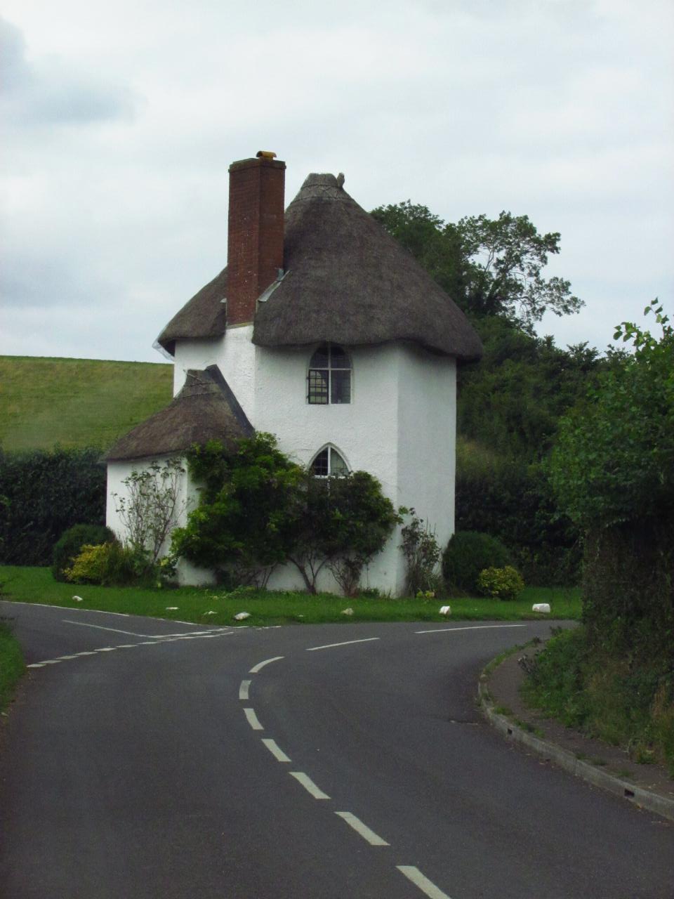
| A lovely thatched cottage in Amesbury |
Woodhenge is is a Neolithic Class II henge and timber circle monument located in the Stonehenge World Heritage Site in Wiltshire, England. It is 2 miles (3.2 km) north-east of Stonehenge in the parish of Durrington, just north of Amesbury. The site consists of six concentric oval rings of postholes, the outermost being about 43 by 40 metres (141 by 130 ft) wide. They are surrounded first by a single flat-bottomed ditch, 2.4 metres (7.9 ft) deep and up to 12 metres (39 ft) wide, and finally by an outer bank, about 10 metres (33 ft) wide and 1 metre (3.3 ft) high. With an overall diameter measuring 110 metres (360 ft), the site had a single entrance to the northeast. At the center of the rings, was a crouched inhumation of a child, which Cunnington interpreted as a dedicatory sacrifice. Over 40 years after the discovery of Woodhenge, another timber circle of comparable size was discovered in 1966. Known as the Southern Circle, inside of what came to be known as the Durrington Walls henge enclosure, located only 70 metres (230 ft) north of Woodhenge. The postholes are now marked by a set of low and elegant concrete markers. Their diameters approximate to the size of posthole found. It has a near summer solstial alignment.
After seeing the Woodhenge it was after 9am so we decided to go back to Stonehenge and experience the henge with the other tourists and hear the information on the earphone headset.
 |
| Heel Stone closer up |
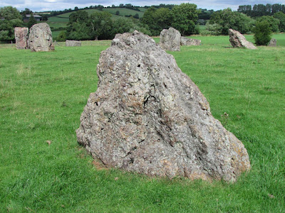
We then drove to Stanton Drew to see the stone circles. Although this is the third largest collection of prehistoric standing stones in England, the three circles and three-stone 'cove' of Stanton Drew are surprisingly little-known. Recent surveys have revealed that they were only part of a much more elaborate ritual site. From the two visible circles there are two avenues running eastward towards the river Chew. The avenue starting from the North-East Ring, composed of seven surviving stones, and the wrecked one extending from the Great Circle, if continued, would have merged into one.
The Cove, in a straight line with the centres of the two accessible stone circles, consists of two huge upright stones with a recumbent slab lying between them. A wedding party was turned to stone: the party was held throughout Saturday, but a man clothed in black (the Devil in disguise) came and started to play his violin for the merrymakers after midnight, continuing into holy Sunday morning. When dawn broke, everybody had been turned to stone by the Demon: so the stone circles are the dancers, the avenues are the fiddlers and the Cove is the bride and the groom with the drunken churchman at their feet. They are still awaiting the Devil who promised to come back someday and play again for them. They have equal importance as Stonehenge.
As you walk between sometimes massive blocks of sandstone, breccia and limestone, some standing, some seemingly strewn around randomly, the whole picture starts to come together. Starting in this large field we first find the Great Circle. A massive 113 metre true circle, it is smaller only than Avebury and contained around 30 stones of which 27 remain with only a handful still standing. Leading from the north east of the circle is the shattered remains of a stone avenue which passes by the smaller Northeast circle. Adjacent to the Great Circle, the Northeast Circle is in fact slightly elliptical and contains 8 stones, 4 still standing. What at first appears to be just a jumble of blocks to the east of this much smaller 30 metre ring is in fact a second avenue, which joins the first and together they would have continued down to the river Chew. Beyond the river, some 350 metres from the Great Circle lies the fallen sarsen block of Hautvilles Quoit. Standing a short distance away from these circles in a different field is the now accessible Southwest Circle containing 11 of a possible 12 original stones.
On the other side of the village, between the church and the Druid's Arms Inn is the mysterious Cove, this comprises of two massive standing stones, one looking like a huge Neolithic golf flag and a third recumbent slab lying between them. What makes this site even more interesting is that there are two different alignments here. The first is through the centres of the Southwest and Great Circle onto Hautville's Quoit, the second is through the Cove and the Great and Northeast Circles. Sites like Stanton Drew always attract their share of legends and stories. It is said that the stone circles are a petrified wedding party who danced on into the Sabbath due to the mischievous Devil's fiddle playing. The bride, groom and parson tried to escape but they too were turned to stone, and now stand as the Cove. This story is similar to many other associated with circles and standing stones throughout the country, and like other sites, the stones of Stanton Drew are said to be uncountable.


 |
| The large Great Circle |
 |
| The avenue towards the Northeast Circle |
 |
| Kevin standing in the centre of the Northeast Circle |
 |
| The second avenue leading away from the Northeast Circle |
 |
| The third Southwest Circle |
 |
| The cove with the bride, groom and drunken churchman |
 |
| This amazing little thatched cottage is set in a triangular roundabout block of ground surrounded by three roads |
We then drove to Burrington Combe a typical Mendip Gorge section through the carboniferous limestone sequence. This overlaying Burrington Oolite forms the prominent crag known as the Rock of Ages inspiring the hymn of the same name.
On the way home we stopped at Pen Hill in the Mendip Hills plateau of Somerset. After our climb to the top of this very high hill housing the Priddy TV transmission tower we were rewarded with wonderful views even though they were a little hazy of the Tor and Glastonbury landscape.

We then called into Wells a wonderful city with the wells or springs, still seen today in the Bishop’s Palace garden, the reason for the original settlement of this area. Stone Age flints and Roman pottery have been found near the springs and the earliest evidence of worship is a Romano-British burial chamber, which may have been Christian. Over this a Saxon mortuary chapel was built and in about 705, A.D. King Ine of Wessex gave permission for a minster church to be founded here. When it rains, water runs off the Mendip Hills and disappears into a system of underground channels and rivers. When it reaches Wells the water hits a layer of mudstone and is forced up through clefts in the rock to form what are known as the springs. On average 4 million gallons of water flow from the springs every day. Native British tribes worshipped nature spirits, dedicating shrines near rivers, streams and springs. Whether they worshipped here, we do not know, though it seems highly likely and evidence of Stone Age flints shows that they visited the area.
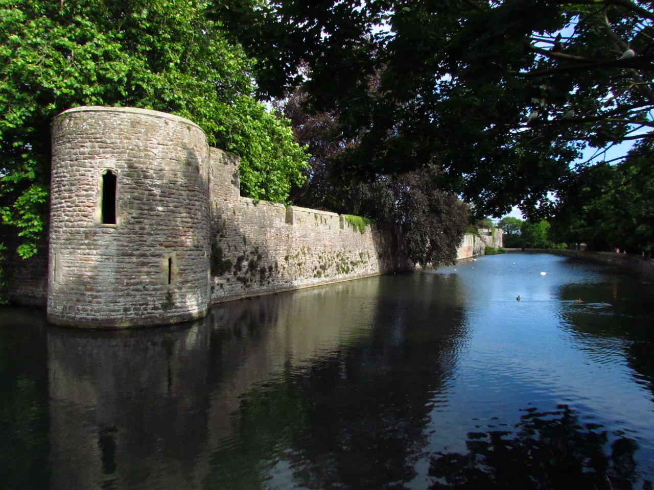
Bishop’s Palace is a medieval Palace and Undercroft, ruined Great Hall, 14 acres of gardens and the Bishop’s Chapel. Home to the Bishops of Bath and Wells for 800 years this stunning medieval palace is surrounded by a breathtaking moat dating from the early-thirteenth century with beautiful well pools Within the tranquil pool in the outer gardens is the source of water from which the City of Wells takes its name. The great quantity of water that surges up from four “pots” within the silt. The average flow from these is 40 gallons (100 litres) per second. From the well pool, the water flows into the moat to discharge over a weir into the River Sheppey.
 |
| Almshouses in Wells |
 |
| Cathedral Green |
 |
| Penniless Porch where beggars asked for alms |
 |
| Bishop's Palace |
 |
| Wells Cathedral |


No comments:
Post a Comment