Today Jan my new friend from the conference Kevin and I drove to Avebury to see the Silbury Hill, West Kennet Long Barrow the Avenue & Stone Circle at Avebury and the white horse.
Our first stop was to see the Westbury White Horse which was recarved in 1778 however there is evidence of an earlier chalk horse being there prior to 1700. The Westbury white horse is the oldest of the Wiltshire horses. It is also one of the best situated, being high on a very steep slope and overlooking a panoramic view.
In 1778, a Mr. George Gee, who was steward to Lord Abingdon, had the horse re-cut to a design nearer to its present day appearance. He apparently felt that the older version was not a sufficiently good representation of a horse. One cannot help but wonder if the name G Gee had made him overly sensitive about horses.
A century later the horse had become somewhat misshapen, and in 1873 it was restored according to the directions of a committee appointed for the purpose, and edging stones were added to help hold the chalk in place. The shape of the present horse dates from this restoration. In the early twentieth century, concrete was added to hold the edging stones in place. In the late nineteen-fifties, it was decided that it would considerably reduce the maintenance costs if the horse were covered in concrete. This work was carried out, and the concreting was repeated in 1995. Whether originally or at a later date, the concrete was painted white. Given that the horse is now concrete, it is perhaps ironic that the marvellous panoramic view from the site of the horse is spoilt only by being bisected by the massive chimney of the local cement works. The works is no longer operating, so perhaps the chimney will be demolished eventually.
 |
| Beautiful thatched property along the way |
 |
| The Waggon & Horses where we had lunch |
Silsbury Hill of all the historical landmarks spread throughout the British Isles Silbury Hill is one of the most remarkable. Accepted as the largest man-made mound in pre-industrial Europe it has a symmetry that makes it seem almost modern. At 130 feet high and covering an area in excess of 5 acres the enormous contours of the hill still challenge us with the mystery of why it was built and what for, but the solution to the mystery of how it has survived for 4,500 years without eroding away has been known from some early excavations.
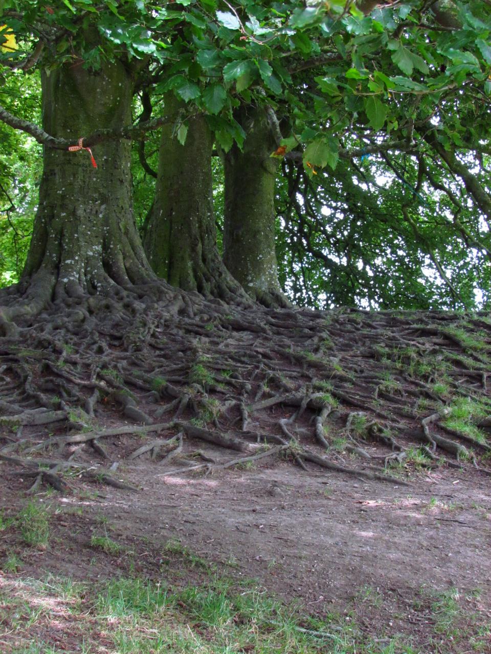
The uppermost part was built as a series of drums each getting progressively smaller in diameter with increasing height. Each drum is about 17 feet in height with the outer wall leaning in at an angle for added stability. The inside of each drum consists of a series of radial walls similar to a spider's web which divide the drums into compartments each of which are filled with chalk the walls themselves having been built with chalk blocks. A recent survey of the hill now indicates that the drums are more in the form of polyhedra than circular and may have been built in such a way as to allow the "steps" to form a spiral trackway leading to its summit. The construction of Silbury demonstrates a high level of sophistication. Surrounding the base of the hill is an extensive ditch which is elongated on the western flank. It is believed that it may have been deliberately filled with water when Silbury was first constructed.


West Kennet Long Barrow is situated on the skyline to the south of Silbury Hill. It consists of a 104 metre long earthen bank with a series of stone chambers at its eastern end. 2.4 mtr high at the left end is a row of large upright sarsen stones. The bank tapers gently away from its chambered end and has the remains of quarry ditches along each side. At around 3700BC it was constructed centuries earlier than Silbury Hill or the Avebury Henge. This is about the same time that Windmill Hill was becoming a settlement. It appears to have been in use up until about 2200 BC when for some reason it was closed off. There is still some mystery about how it was used. It is obviously of some funerary importance as when excavated the remains of 46 people were found within the stone chambers, at least a dozen of whom were children. The West Kennet Avenue connects the south entrance of the Avebury Henge to the Sanctuary one and a half miles away on Overton Hill. The avenues were the last components of the henge to be constructed at around 2400 BC. That of the West Kennet is believed to have consisted of about 100 pairs of stones spaced at intervals of 80 feet with the avenue being about 50 feet wide throughout much of its length though it may have narrowed as it approached the Sanctuary.


 |
| Overton Hill |
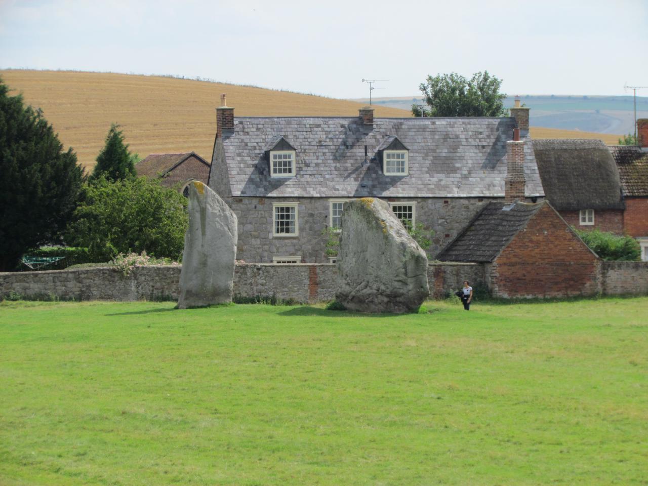
Avebury Stone Circle is the largest stone circle in the world 427m in diameter over 28 acres. It is estimated that the henge and avenues originally contained well in excess of 600 stones but so many have been destroyed that only 76 of them are now visible though excavations and surveys in recent years have revealed that at least 20 others remain buried.
The Cove with the two cove stones contained within the remnants of the northern inner circle which are amongst the largest and finest stones of the whole monument. It has long been accepted that the stones of Avebury represent male and female characteristics with the two surviving cove stones being perfect examples of the types chosen. At the north side there once was a third stone which completed the cove and faced the existing slender "male" stone. This fell in 1713 and was destroyed.
The obelisk the central stone to the southern inner circle stones. A large concrete plinth now marks the position where one of the largest of Avebury's stones once stood. Known as "The Obelisk" it was the central stone of the Southern Inner Circle and survived long enough for William Stukeley to record it. Lying on its side when he saw it he described it thus: "The central obelisk of this temple is of circular form at base, of a vast bulk, 21feet long and 8 feet 9 inches in diameter; when standing, higher than the rest". Apart from the coves the inner circles were the earliest components of the Henge to be built. At about 2900 BC they pre-date by several centuries the final henge and avenues. One of the outer stones of the Southern Inner Circle has such an obvious female feature that some researchers have christened it the "Vulva Stone". Left hand stone of the southern inner circle stones. Given the sexual overtones that permeate much of the fabric of Avebury it seems likely that this stone was deliberately selected for this aspect of its appearance. Together with the "Obelisk", the phallic appearance of which can be inferred from Stukeley's description of it, there is a strong hint that the South Circle's function was primarily concerned with the rituals of fertility and re-generation.
The Entrance stones – The Devils Chair stones to the right side the avenue in the bottom of the circle. Apart from the Obelisk and the components of the Cove in the northern inner circle the largest stones used in the construction of the henge were those at either side of the entrances on the outer circle. Fortunately three of these remain in position so that we can still stand beside them in awe of their 60 ton bulk and the effort it must have taken to move and erect them.
The Swindon Stone at the left side of the avenue to the northern entrance. Unfortunately the diamond-shaped "Swindon Stone" that stands dramatically close to the road at the north entrance has lost its partner which reportedly fell in 1722 and was destroyed. As well as the mighty stone no.73 at the east entrance to the left of the avenue now on it’s side it is worth a visit to see the spectacular tree roots that cover the outer bank nearby. It is reported that "Lord of the Rings" author J.R.R.Tolkien derived some of his inspiration from visiting this natural wonder at Avebury.
Another point to consider is the substantial amount of modifications to the bank and ditch that have taken place at the entrances since the henge was built. The modern roads don't reflect the precise positions of any of the original entrances. Most severely altered has been the southern entrance where today's road runs over the infilled ditch with the original causeway remaining to the east and aligned with the two massive entrance stones. The section of bank at the south entrance on which the familiar group of large trees now stand is in fact an 11m extension added sometime after the 16th century. This makes it confusing to visualise quite how the avenue originally joined the henge.
One of the features of the stones at Avebury which always seemed curious was the amount of holes many of them display. The stones were formed from sedimentary material containing plant roots. These remained present long enough to leave their signature.
The Sanctuary is the site of a stone circle that once formed the terminal point of the West Kennet Avenue. Large enough to contain the outer ring of stones at Stonehenge its earliest parts are dated to around 3000 BC which is about the same period the cove in the northern inner circle of the henge was erected. Unless any evidence to the contrary is found it is believed to have only become linked to the distant henge when the avenue was built about 2400 BC. Now destroyed and only consisting of small concrete markers where the various elements once stood, the Sanctuary must have played an important part in the function of the henge.
The Long Stones about a mile outside the main circle of the henge and on the line of the Beckhampton Avenue stand two large stones. With some interesting lichens adorning their surface they are known as the Longstones (also known locally as"Adam & Eve"). The larger of them, according to a drawing made by William Stukeley, is the surviving component of a cove similar in structure to that in the north circle of the henge; the other belongs to the avenue. Recent excavations have confirmed the existence of this cove.
 |
| The Avenue |
 |
| Arriving at the Entrance Stones to the henge from the Avenue |
 |
| The great ditch that runs all around the henge |
Hackpen Hill White Horse is near The Ridgeway on the edge of the Marlborough Downs, two miles south east of Broad Hinton village, on Hackpen Hill where the Wootton Bassett to Marlborough road zigzags up the hill. Its origin is uncertain. It may have been cut in 1838 by a Henry Eatwell, Broad Hinton parish clerk, perhaps with the assistance of the landlord of a local pub, to commemorate the coronation of Queen Victoria. This white horse is on a comparatively shallow slope, but is partly banked up to make it more easily visible.
 |
| Hackpen Hill White Horse |
 |
| Standing right next to the horse you can see the white chalk they are made from |
 |
| Another wonderful cottage along the way the thatchers create small creatures out of the thatch to scare off birds to prevent them from nesting in the roof this one has ducks |
The Uffington white horse, one of only four that face to the right, is high on an escarpment of the Berkshire Downs below Whitehorse Hill, a mile and a half south of the village of Uffington. It is cut, not on the steepest slope of the hill, but on the much shallower slope near the top, and can only really be viewed well from afar or from above.
This is by far the oldest of all the white horses, and is of an entirely different design to the others. Unlike the solid and more or less naturalistic figures of the other horses, the Uffington white horse is formed from stylized curving lines some ten feet or less wide, and its length of around 365 feet makes it over twice as long as the longest of the Wiltshire horses. Whether it is indeed intended to represent a horse, or some other creature instead, has been debated, but it has certainly been called a horse since at least medieval times. A cartulary of the Abbey of Abingdon from between 1072 and 1084 refers to "the place commonly known as the White Horse Hill" ("locum qui vulgo mons albi equi nuncupatur").
Until 1995 the Uffington white horse was thought to date from the Iron Age. However, in the nineteen-nineties, a new dating technique was developed. This technique, optical stimulated luminescence dating (OSL), can show how long soil has been hidden from sunlight. The lines of the horse consist of trenches dug in the hillside, then filled with chalk. OSL testing of soil from between the lower layers of that chalk shows that it has been buried since between 1400 BC and 600 BC, and probably between 1200 BC and 800 BC, and thus the horse is of Bronze Age origin.
The original purpose of this horse is unknown. It may have been the emblem of a local tribe, and have been cut as a totem or badge marking their land, or it may have had a religious purpose or significance. The horse-goddess Epona was worshipped by the Celts in Gaul, and she had a counterpart in Britain, Rhiannon, so the Uffington white horse may have been cut by adherents of a cult of the horse-goddess. Alternatively, the horse could have been cut by worshippers of the sun god Belinos or Belenus, who was associated with horses. He was sometimes depicted on horseback, and Bronze and Iron Age sun chariots were shown as being drawn by horses. Conceivably, if this suggestion is correct, the horse could have been cut on the shallower slope at the top of the hill in order to be seen from above by the god himself.
Dragon Hill, a natural mound named after its association with a legend of St George. The mound, which is around 10 meters high, is located nearby to the famous and enigmatic horse.
 |
| Dragon Hill |
 |
| Uffington White Horse |


No comments:
Post a Comment