Last night we walked through the streets of Kirkwall, seeing the only tree that was left in Orkney many years ago - now people have started planting trees once again. We also went to see the St Magnus Cathedral.
 |
| The tree of Kirkwall |
 |
| St Magnus Cathedral |
 |
| The Town Hall of Kirkwall |
Today we went exploring the ancient past of the Orkney Islands. The first place we called into were the Standing Stone of Sterness. Standing at a maximum height of six meters (around 19 feet), the sheer scale of the megaliths that make up the Stones o' Stenness, make the monument visible for miles around. Located by the south-eastern shore of the Loch o’ Stenness, only four of the ring's stones remain. The Standing Stones o' Stenness were originally laid out in an ellipse. Although it is commonly written that the monument was once made up of 12 megaliths, execavations in the 1970's suggest that the ring was never "completed", with at least one - possibly two - of the 12 stones were never erected. Radio-carbon dates from the excavation show that the site dates from at least 3100BC, making the Standing Stones complex one of the earliest stone circles in Britain . Like the Ring o' Brodgar, the Stenness ring has been classed as a henge monument. The stone circle was originally surrounded by a rock-cut ditch (four meters across and 2.3 meters deep), outside of which was a substantial earth bank. With an approximate diameter of 44 meters (144 feet), the earth bank had a single entrance causeway on the north side, facing the Neolithic Barnhouse settlement on the shore of the Harray loch. Little remains of the bank, or ditch, today, although traces remain visible around the stone circle. Today, at the center of the ring, there is a large stone hearth. The hearth was constructed from four large stone slabs, and, according to Dr Colin Richards, the excavator of the nearby Barnhouse Settlement, an earlier hearth was transplanted from Barhouse to the center of the stone ring. Close to the hearth stand two angular slabs, standing side by side, with a large prone stone beside them. This is the remains of the "dolmen" rebuilt in 1907 - although doubt remains that it was ever part of the original complex.

 |
| Showing the central hearth of the stones |
We then visited the Barnhouse Village on the south shore of the Harray loch, on a point of land called Antaness, around 150 metres to the north of the Standing Stones o' Sterness, are the remains of an Orcadian Stone Age settlement. Now known simply as the Barnhouse Settlement, only the reconstructed lower courses of a small section of the village's stonework are visible today. Excavations uncovered evidence of 15 small dwellings in varying stages of development. The structures were round - perhaps with timber and turf roofs - with turf cladding surrounding the outer walls. Because there were no roofed passageways between the huts - such as those at Skara Brae - it appears that the Barnhouse dwellings were free standing and not encased in midden. But particularly intriguing was the fact that each building appeared to have been deliberately demolished at the end of its life.
 |
| Our last glimpse of the Standing Stones of Sterness |
The Ring of Brodgar was our next visit. Part of the Heart of Neolithic Orkney World Heritage Site, the Ring o' Brodgar is found in the West Mainland parish of Sterness. It stands on an eastward-sloping plateau on the Ness o' Brodgar - a thin strip of land separating the Harray and Stenness lochs. Because the interior of the Ring o' Brodgar has never been fully excavated, or scientifically dated, the monument's actual age remains uncertain. However, it is generally assumed to have been erected between 2500 BC and 2000 BC, and was, therefore, the last of the great Neolthic monuments built on the Ness. The stone ring was built in a true circle, almost 104 metres wide. Although it is thought to have originally contained 60 megaliths, this figure is not based on archaeological evidence. Today, only 27 stones remain. In contrast to the giant megaliths that make up the Standing Stones o' Sterness, the Brodgar stones are much smaller, varying in height from 2.1 metres (7 feet) to a maximum of 4.7 metres (15ft 3in). With a diameter of 103.6 metres (340 ft), the Brodgar ring is the third largest stone circle in the British Isles. Covering an area of 8,435 square meters (90,790 square feet), it is beaten only by the outer ring of stones at Avebury and the Greater Ring at Stanton Drew in England. Incidentally, the Brodgar ring is exactly the same size as Avebury's two inner rings. The stone circle is practically in the center of a massive natural "cauldron" formed by the hills of the surrounding landscape. Today, the site is accentuated by the water of the lochs, but that was not always the case. In fact, when the ring was erected, between 2500BC and 2000BC, the Stenness loch didn't exist. Instead the area was wet, marshy bog, surrounding pools of water or lochans. The sea only breached the narrow landbridge at the Brig o' Waithe in Stenness, filling the loch was salt water, around 1500BC - 500 to 1,000 years after the ring was built. The Ring o' Brodgar was part of an enormous prehistoric ritual complex that incorporated the Stones o' Stenness, approximately one mile to the south-east, and, probably, the Ring o' Bookan to the north-west. A short distance to the east of the Brodgar ring is the solitary standing stone now known as the Comet Stone. The area surrounding the Ring o' Brodgar, and the entire Ness, is rich with archaeology - including four massive mounds thought to have been created between 2500 BC and 1500 BC.


 |
|

 |
On the southern shore of the Bay o' Skaill, in the West Mainland parish of Sandwick, is the Neolithic village of Skara Brae - regarded by many as one of the most remarkable monuments in Europe. In the winter of 1850, a great storm battered Orkney. There was nothing particularly unusual about that, but on this occasion, the combination of wind and extremely high tides stripped the grass from a large mound, then known as "Skerrabra". This revealed the outline of a number of stone buildings — something that intrigued the local laird, William Watt of Skaill, who embarked on an excavation of the site. In 1868, after the remains of four ancient houses had been unearthed, work at Skerrabra was abandoned. The settlement remained undisturbed until 1925, when another storm damaged some of the previously-excavated structures. A sea-wall was built to preserve these remains, but during the construction work, yet more ancient buildings were discovered. Further excavations followed and, between 1928 and 1930, the dwellings we see today were released from their protective cocoons. At the time, the village was thought to be an Iron Age settlement, dating from around 500BC — but this was no Pictish village. Radiocarbon dating in the early 1970s confirmed that the settlement dated from the late Neolithic — inhabited for around 600 years, between 3200BC and 2200BC. Today, Skerrabra — or Skara Brae as it has become known — survives as eight dwellings, linked together by a series of low, covered passages. Because of the protection offered by the sand that covered the settlement for 4,000 years, the buildings, and their contents, are incredibly well-preserved. Not only are the walls of the structures still standing, and alleyways roofed with their original stone slabs, but the interior fittings of each house give an unparalleled glimpse of life as it was in Neolithic Orkney. Each house shares the same basic design - a large square room, with a central fireplace a bed on either side and a shelved dresser on the wall opposite the doorway.
|
 |
| The reconstructed house to give a better feel for what the remains present here today would have looked like |
 |
| Skail House where the William Watt of Skaill the local laird lived |
 |
| Look closely at the old style of safe behind the book shelf |
Whilst driving over the center of the island we came across this peat moss freshly dug to dry before being taken home to burn in the fires of the locals, this is an alternative to wood as there are no trees on the island.


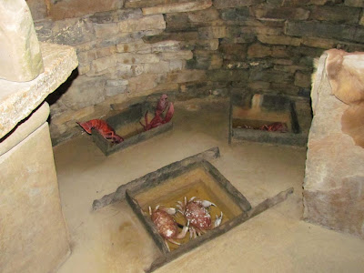
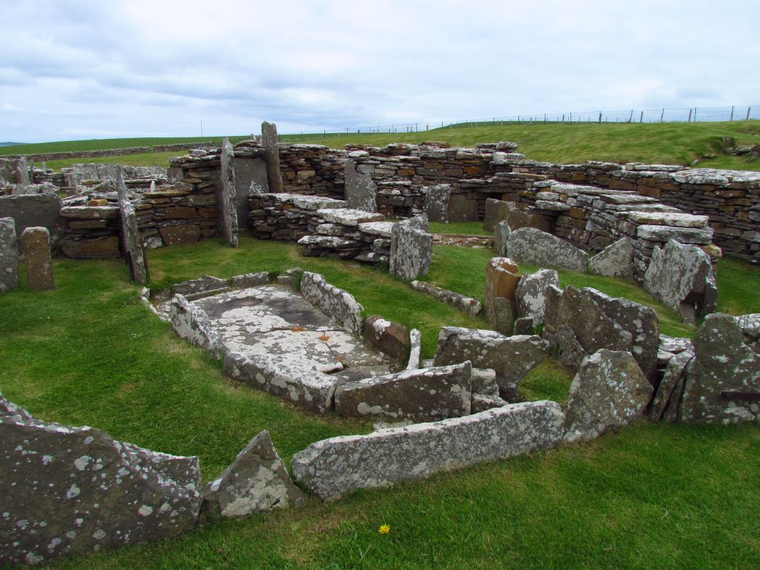
Broch o' Gurness - Dates for the broch are unclear, but it is generally agreed that it was built between 200BC and 100BC - possibly on the site of an earlier settlement. Standing around eight metres high (26 feet), with an internal diameter of 20 metres (65 feet), the broch was a tall, easily-defended, tower, surrounded by a series of small stone dwellings. The entire settlement was circled by outer defences comprising of a band of three ramparts and three ditches. The sprawl of stone houses filled all the available space between broch and the outer defences, and probably housed a community of up to 40 families. The semi-detached stone-built dwellings were partitioned off into separate living areas, each contained a hearth, stone furniture, and even a recognisable toilet. The broch itself was accessed by an entrance causeway on the eastern side of the settlement. Houses line this causeway giving the appearance of a processional path. As time progressed, the broch's defensive role decreased, until around 100AD, after years of neglect, it was finally abandoned and its upper sections dismantled - probably to provide the building material for later houses in the area. During the years of its occupation, a number of alterations were made to the interior of the broch but the original rectangular hearth and an underground chamber containing a spring-filled water tank are visible today. This chamber, typical of a number found at sites across Orkney, is very similar to the underground chamber discovered at Minehowe in 1946.
 |
|

 |
|


 |
| See the areas used for grinding on the slab rock |
 |
|

Bishops & Earls Palaces near St Magnus Cathedral are regarded as two of the finest examples of architecture in Scotland and highlight Orkney’s strong Norse and ecclesiastical links. One of the main attractions is the monumental fireplace in the great hall of the Earl’s Palace, built in around 1600. The Bishop’s Palace was built around the same time as St Magnus Cathedral, in the early 12th century. The Earl’s Palace, built by Patrick, Earl of Orkney, is an epic space that still has the power to impress. Built for Bishop William the Old in the 1150s, and known as the Palace of the Yards. The building was already over a hundred years old when King Håkon IV of Norway took up residence in 1263 following his defeat by Alexander III (and the weather) at the Battle of Largs: The palace fell into disrepair in the following centuries before being extensively rebuilt by Bishop Robert Reid (the founder of Edinburgh University) in the 1540s. It was Reid who added the round tower that is today the most striking feature of the Bishop's Palace. In 1568 the palace was acquired by Earl Robert Stewart, whose family then effectively enslaved the islands for over 40 years. Today the Earl's Palace hides away behind a thick screen of trees, but it is generally agreed to have been the finest Renaissance building in Scotland.
 |
| Earl's Palace |
 |
| Great Hall |
 |
| Bishops Palace |


2 comments:
What a beautiful place. And even the weather was ok.
What a beautiful place. And even the weather was ok.
Post a Comment