Today we drove out of the rocky mountain country to the ocean and the Dingle Peninsula. The countryside changed so much to further away we drove turning to sweeping valleys of pasture and oh so green valleys.
This mountainous finger of land which juts into the Atlantic Ocean has supported various tribes and populations for almost 6,000 years. Because of the peninsula's remote location, and lack of specialised agriculture, there is a remarkable preservation of over 2,000 monuments. It is during this period that the first farmers appear, living in more permanent structures, and showing a certain skill with the craft of pottery. Stone is the main material used in tool and weapon making. Large stone tombs are built to house the dead, and possibly also for ritual use. Some of the tombs of this period show incredible architectural skill in their orientation on the setting sun during the Winter Solstice. From 2500 BC changes begin to occur. Knowledge of exploiting copper, and later the production of Bronze, appear for the first time. This was to become a time of great change in Ireland, especially in the southwest of the country, where considerable deposits of copper were exploited. It appears that a new population of people from the south arrived at this time, with new technologies and developments. Stone circles, stone alignments (orientated on the rising and setting sun), stone pairs, standing stones, wedge tombs, ancient eating places (fulachta fiadh), cist graves, and possibly some of the rock art and shell middens are the main monuments associated with the Bronze Age. Unfortunately, it is difficult to identify any of the habitation sites used during this period; but the artifactual evidence certainly makes up for this. Ireland has the second largest collection of gold work in Europe, in the form of lunula, collars of gold, bracelets, earrings, hairlocks, gold balls, and gold boxes. There are hundreds of bronze implements, vessels, and weapons, each type showing their development through the Bronze Age, each one becoming more complex and efficient. The Loch a'Dúin valley near Cloghane contains the most remarkable series of monuments from the Bronze Age. In this valley of 1,500 acres, there are 90 stone structures dating from 2500 BC up to modern times. Running like a web throughout the landscape are several miles of stone wall, hidden by peat which has accumulated over the past 3,000 years. From archaeological excavations and pollen studies, it has become clear that the Loch a'Dúin Valley was used for intensive agriculture, both pastoral and arable, from 1600 BC to the beginning of the Iron Age. During this time habitation huts, fulachta fiadh, standing stones and enclosures were erected to house both humans and animals. Even earlier are the wedge tomb and the cup and circle rock art (of which there are nine examples), making it the largest concentration on the Dingle Peninsula. The level of preservation is due to the protective cover of the bog which completely covered the landscape. It is during modern turf cutting that the ancient remains are uncovered. The peat preserves all organic materials to a remarkable degree. Birch wood found during the excavation of a section of pre-bog wall was preserved perfectly. The bog also holds all of the pollen which was released from the vegetation over the past several thousand years, enabling the botanist to discover what grew in the valley in the past. Also belonging to this period is the ancient pilgrimage to the summit of Mount Brandon. This was ritualistically done on the last Sunday of July, known locally as Domhnach Chrom Dubh. Initially it was part of a worship to the Celtic God Lughnasa as part of the harvest festival. Later it became Christianised and was dedicated to St. Brendan, a 6th century monk who is said to have sailed to America long before Columbus. The story of his voyage was translated into every European language by the 12th century, and made Brendan famous as a seafaring saint. It was from the summit of Mount Brandon that Brendan had a vision of "the land to the west". The route of the old pilgrimage is clearly marked to the summit of Ireland's second highest mountain.
Strong headlands are said to be the remains of a great volcanic explosion that occurred when the lost continent Atlantis sank into the sea. The land is sacred to the Goddess Dhoibhne.
 |
| One of the lovely building driving along the road |
Our first stop of the day was Bunratty Castle & Folk Park. Bunratty Castle, built in 1425, is the most complete and authentic medieval fortress in Ireland. Bunratty Folk Park, set on 26 acres, is a stunning recreation of 19th Century Ireland and features various types of farmhouses, a church, a magical walled garden and village street complete with pub, post office and various shops. Featuring over 30 buildings in a ‘living’ village and rural setting. Meet and chat with the Bean an Ti (Woman of the House). Bunratty Walled Garden, modelled on the original Regency period garden which supplied fruit, vegetables, and flowers to Bunratty House built in 1804 and now refurbished in typical Victorian style.
 |
| The tearooms |
 |
| Peat burning in the fire place creates a distinct smell throughout the cottages |
 |
| Here the peat is stored outside the front door under straw to keep it dry in the landless labourer's home |
 |
| Horizontal Mill a working corn mill |
 |
| Ardcroney Church rebuilt stone by stone from the original town Ardcroney to the Folk Park |
 |
| The Regency Garden overlooking the Owenogarney River & Shannon River |
 |
| The Doctor's House |
 |
| Gypsy Wagons |
 |
| Golden Vale Farmhouse home to a farmer from the rich lands |
 |
| Bunratty Castle |
 |
| Sheela-na-gig in the Window alcove of the castle |
 |
| Mountain Farmhouse a poor farmers home from the borders of Limerick & Kerry |
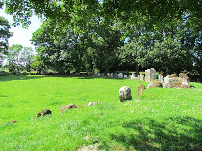
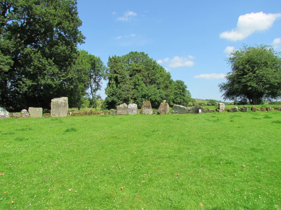
We then stopped at the Grange Stone Circle at Lough Gur. The Irish name for this is Lios na Grainsi and it translates to mean 'Stones of the Sun'. This site is older than the later phases of Stonehenge. The Grange is the largest standing stone circle in Ireland and one of the most impressive. It is 150 feet in diameter and is enclosed by 113 standing stones. The largest stone is Ronnach Croim Duibh (the prominent Black Stone) and is over 13 feet high and weighs 40 ton. The stone circle is aligned with the rising sun at the Summer Solstice so on that morning the sun shines down directly in the centre of the circle. The entrance stones are matched by a pair of equally impressive slabs on the southwest side, whose tops slope down towards each other to form a v-shape. It has been calculated that these stones and the entrance way were aligned with the sunset of the Festival of Samhain. No one is exactly sure what kind of rituals occurred here. No structures were found but excavations did discover two hearths, a few un-burnt human bones, some animal bones (Mainly cattle) some bronze materials and numerous Neolithic pottery pieces.
Lough Gur formed by Goddess Aine who appears in different forms as a mermaid, a young woman and a hag. As mermaid she raises from her transitional home beneath the sacred waters of the lake. As maiden she empowers the land's human custodians as hag she defends her realm.
As I walked among these grand stones hundreds of vivid blue Damselfly's took flight and made it a most wondrous place. The locals believe strongly that this is a place of fae in the nights hours and it seemed so fitting that the damselfly's were so plentiful here.
 |
| The stone on the right is the Black Stone |
 |
| The entrance stones forming the V shape |
We then continued on our way to Dingle stopping at the viewpoint on Connors Pass to take in the view.
We then arrived at our home for the night Ceann Tra Heights B & B and this is the wonderful views from our room.


No comments:
Post a Comment